Over the last year, we have provided you with information on what we believe to be the top five walks across Enniscorthy, Wexford, and Gorey...
In this article, we pinpoint the top five walks across the Bunclody area and the Blackstairs Mountains.

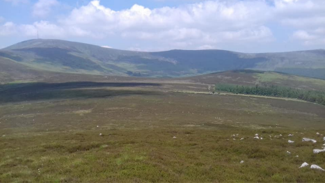
No.5 Coolmelagh Forest and Gibbet Hill
Just a few miles east of Bunclody, just beside the Carnew road, Coolmelagh Forest is an oasis of calm in our busy lives and Gibbet hill summit holds breath-taking views across parts of North and Central Wexford.
The car park is just inside the hedge line beside the field: enter the stone lane between the trees. Take the first left and immediately you will face a fork in the track, travel left here and continue for two kilometres ignoring one branch to the left. The land on this two kilometre stretch gives way to lovely evergreen forest mixing with farmland to your left and with views north into county Wicklow. There is a smattering of native trees to your right. Occasionally, up here you may spot some deer who have got a bit bored of the Wicklow Mountains and fancy a venture into Wexford.

You will eventually hit a hairpin bend. Just go round it and then you will be within the forest proper as it really wins out here on both sides in a very relaxing part of the route. Continue on the main wide forest track. Ignore the major tracks. After 750 metres ignoring your first major left and then going in a snake like manner till the next major left. Take it briefly to experience the fantastic engineering sceptical that is two large wind turbines, creating massive amounts of electricity in an Environmentally friendly manner. The bank at the second turbine particularly gives great views south and west across county Wexford. Hitch back onto the main track heading onward. Ramble onwards ignoring the main track to the right and a small track to the left. You then proceed on a u-shaped bend ignoring the small and then bigger track to the left, instead taking the third option.
Walk straight on up to the holy year cross which overs stunning views to the Blackstairs Mountains and to the South across Wexford’s rich farmland and the Slaney Valley. This is Gibbet Hill and the High Point of your walk at 317 metres high, hence the gorgeous views. As the name suggests, this must have been once a execution via hanging site years ago. Head back to the U bend always looking out for birds, wildlife and interesting flowers on the trackside. After this bend in about 550 metres you will hit a major Y shaped fork in the track, Head left and after 600 metres of relaxing forest walk you will be on the straight stone Lane you originally set out on and you’ll be at your car in 5 minutes.
This Carpark is located on google maps at 52.686299, -6.579996
No.4 Carraigalachan, Carraigroe and Bran Scultair Mountains
A walk along the southernmost ridge of the Blackstairs Mountains is a beautiful and handy walk to complete on a nice sunny winters day. You access this ridge of Mountains at a small carpark at the end of Ballybaun lane. Here skip past the forest barrier and continue along the forest track. After a short time you will enter the beautiful, vast and historic Bantry forest. There has been woodland of some sort here for centuries.
Continue on through a double hair pin bend, first swinging left, then right. Walk on through till you come to another hairpin, except this time you will continue straight instead of heading left with it. Now you will be in open country on a rocky trackway. You will again be on historic ground as believe it or not this is an ancient road going from Wexford into Carlow. Where you are now is called Cooliagh gap / Mam a Chuliagh. Check if you are exactly on the county boundary and if you are heading immediately left up the
Slope basically following the edge of the Forest south up to the summit of Carraigalachan Mountain at 463 metres. The mountain top is bounded by Bantry Commons forest on the Wexford side but offers great views into county Carlow and Kilkenny and North to Blackstairs Mountain and Mount Leinster. You may spot a few Hang Gliders showing off high in the sky to the North, cute black faced Mountain sheep and lots of lovely purple Heather. Continue south, remembering that you will be always walking with the forest right beside you, this will help with navigation, down slope briefly and be on the look out all the way as you walk adjacent to the forest as sometimes the occasional small group of deer can pop in and out on their rambles. They are an amazing sight.
Continue on straight and now uphill to your next wee summit Carrigroe Mountain. It’s probable the name comes from Carraig meaning rock and roe possibly rua meaning red. Again stunning views greet you into south county Carlow and Kilkenny including Brandon Mountain and the Barrow Valley. The forest, local animals and heather make a lovely relaxing surround for you hear and I’d suggest a picnic on this, the most scenic of the three mountains on todays climb on the ridge.
The beautifully Gaelic named Bran Scultair Mountain will be in your eyeline to the south along the county boundary topped with it’s tell-tale Masts. Proceed down Carraigroe Mountain, briefly heading along flatish ground before ascending your last and slighty higher Mountain Bran Scultair at 515 metres high.Bran means Tor which is essentially a large free standing rocky outcrop which stands slightly above the ground surrounding it. Tors occur when a rock for example granite is weathered by wind and rain and ice less than the rocks around it leaving it to stand solo in modern times. Scultair is possibly a placename or persons name in antiquity. In the summer time the local Fraughan / Froachan bushes supply a tasty treat or collectable for
tarts and muffins etc with their berries, basically a mini blueberry in appearance. Take a breath and enjoy the views south towards New Ross, the Rivers Nore and Barrow and possibly the Comeragh Mountains in Waterford to the south west.
Return the way you came back to the car. This walk should take your average hiker about 3 Hours.
A spot to park the car is located on google maps at 52.514397, -6.809682
No.3 Blackrock Mountain
Blackrock Mountain is the easternmost summit of the Blackstairs Mountains standing at 599 metres high, directly east of Mount Leinster Summit.
The mountain can be accessed by parking at the Forest trail barrier at Mullaunasmear near Bunclody town. Walk along the forest track. Once you hit the forest travel about 200m then
ignore the small track to the right continuing forward. Head on straight for approx 400 metres and then bear right at a hairpin kind of bend. Mosey on up till you get to a kind of junction in the trail , one going right, but take the left option. Head on for 200/250 metres and you will see a farm gate and open mountain grassland past it. Head over the gate but turn immediately right up the hill with the stone path under you and forest on the right. Just pure continue straight up the mountain side in what is a challenging section but with stunning views behind you into the Wexford countryside. You will enter an almost mini zig zag section way above, but the Mountain is slightly to the left and above you. Check maps if needed with All trails being a good app. The summit of Blackrock Mountain is marked by a Mountain top cairn (small pile of stones). The top offers great views across to Mount Leinster to your immediate west and the picturesque Ballycrystal area will be beneath it to the left. Great views of the Wicklow Mountains are to the North East including Lugnaquilla. County Wexford is to your east and south.
You can use all trails to get back the other side of the forest or to avoid confusion, return to the car the way you came up. A spot to park the car for the Blackrock mountain walk is located on google maps at 52.620896, -6.702784
No.2 Blackstairs Mountain.
Blackstairs Mountain is an imposing Mountain in the southern section of the Blackstairs Mountains near Kiltealy village. The feeling of summiting this 734 metres high mountain is really exhilarating and joyous with special views north to Mount Leinster, East to county Wexford, west to county Carlow and south to the southern ridge of the Blackstairs Mountains. Summiting this mountain is going to feel good as it’s a proper tough challenge and off road too which is always fun as you do very much feel in the middle of nowhere with only cute streams, puzzled sheep, birds and open mountain grasslands to see. This would be a god hike with friends of a god fitness standard as these scenic hikes can be serious craic in a team bonding type of way.
I’d advise an Osi or local map alongside the All Trails app, compass, fully charged phone, warm and water proof clothes, plenty of food and water for this one. You can get a local map in Bowe’s shop in Kiltealy along with banana’s, water, chocolate and yogurts.
Access the forest trail beside the road at a small Coillte forest entrance and follow the path past the barrier and another farm style gate. Burst on up the trail and then it will even out after a while as it comes out of the forest offering absolutely stunning views to your left across a vast swathe of county Wexford and it’s gorgeous countryside. The path comes to a small open area before narrowing significantly going between forest on the right and bushes on the left. After a short walk the path forks, one the left, one uphill to the right. Continue right and then cross the small farm gate, where you are now actually on open Mountain grassland and not an actual farm. Head left and cross the tiny stream, which is the Askinavilar stream.
It gets a bit boggy here until you climb up out of the streams catchment area. In front of you stands the Blackstairs Mountain. Looking left for a breather will give you glorious views over the Farmlands, hills and Coast of the Irish sea including Bree hill, Enniscorthy and Wexford Harbour. Just keep heading up towards the Mountain top and if you get lost somehow get lost just follow the county boundary as Blackstairs Mountain summit is on the border. The scenery, flora and fauna are lovely hear and it comes with a great sense of chilling out. The top of the Mountain is easily distinguished with it’s summit pile of stones heaped in a conical formation and possibly still has bits of bunting attached.
The eroded bog hags ( lumps of peat with grass tops) are pretty cool to see along with the granite stones which makes it look slightly lunar. Have a well deserved flask of tea and a few sandwiches.
Return to car the same way you came and perhaps a celebratory pint for the passengers in Bowe’s of Kiltealy and a bit of craic is the job after a great hike.
A spot to park the car is located on google maps at 52.573565, -6.771910
No.1 Mount Leinster.
Now we are at the business end of the Blackstairs / Bunclody area walks. Mount Leinster from a route like you have never heard of before and Wexford’s best kept hiking Secret. This is a fabulous route that nit many people know about, but is breathtakingly beautiful the whole way and is a mostly Wexford only hike to the top of Mount Leinster. This hikes start is at Clorougemore townland near Kiltealy village. You can stock up on supplies such as a local map, energy snacks and other food’s and water in Bowe’s shop in the middle of the village. Once you park up at Clorougemore you can hop the fence and you will be straight onto a legal right of way at the small wall in the left of this field. Head straight up to the right of the wall and then skirt through a gap in rocky outcrop about 350 metres up from the start of the Field. Use the the end of the wall as a guiding point, looking to basically head straight up the hill from it. Taking breaks check back behind you to spot magnificent views of Wexford beneath you. You are well on the way to ascending the first leg of the hike Clorougemore or Tullawn Hill as it’s
Irish name which means little hill. This hillside is covered in beautiful heather and cool Flowers. Continue on until you spot the summit of the hill which is marked by a pile of stones. A local farmer has told me he can spot boats in Rosslare Harbour from the here and you can easily spot Blackstairs Mountain, Forth Mountain, Wexford Harbour, the Enniscorthy area, Mount Leinster slightly to North-west and parts of north Wexford from here too. It is a gorgeous spot and certainly worth a few minute to sit down and take in the views, while grabbing a breather and a snack. You will notice a tumble down house to your North, head down to it for a gander and then beyond to a pair of standing stones which can be found on the national monuments maps. Trek to the edge of the forest on your right which is a good marker for orientation.
This point is located at 52.592281, -6.754969 on google maps. Head directly west towards Stoolyen, the left hand shoulder of Mount Leinster’s top (the mast topped mountain) which is about a mile from your forest edge, crossing a beautiful bog cotton filled bog, before the climb to Stoolyen’s incredible Lunar like, rocky scene. You will notice at this crest that you are now on the Carlow/Wexford county border and thus just use this as a way of hiking along the border all the way to Mount Leinster’s summit T.V. mast.
The last twenty minutes is hard going but break for glorious views south to Blackstairs Mountain and across county Wexford to the east. Watch out for mountain hares and buzzards along here. On reaching Mount Leinster look all around you to view South Leinster in all it’s glory including the Wicklow Mountains, southern Blackstairs and the Barrow Valley. It is simply Stunning. The summit cairn is the burial mound of King Cucorb, a king of Leinster in the Gaelic Saga’s. In Irish Mount Leinster translates to An Stua Laighean, possibly meaning the warrior of Leinster but some people think it has a different meaning.
Descend the Mountain along the border, till you reach a kink in the borderline then follow the Northern side of the headwaters of the stream valley of the Aughnabrisky river. You will hopefully spot the Red Van below you. Yes, it’s literally a Red Van in the middle of the bog. Head for this and then match yourself up with Tullawn hill which is to your east. Ascend the hill and then down the hill to your car. Animals spotted on the walk are lots and lots of Sheep, ready for an obligatory photo and possibly Mountain hares, kestrels, butterflies, Falcon’s etcetera.
The hike is a photographer’s dream with lots of amazing opportunities to snap unreal photo’s. If you fancy as a passenger a smooth celebratory pint and chat, the two pubs in the village are closely for inspection.
The parking spot for this hike is located on google maps at 52.57919123, -6.747091.
*Please remember the top 4 hikes can be potentially dangerous and it is advisable to arrive early to these hikes given that nightfall comes early in the Winter. Give yourself at least 3 if not 4 hours for the top 4. I am a very experienced hiker myself (I’ve ticked off 39 Wicklow Mountains and all the Blackstairs). Just treat yourself to a day when it’s sunny all day. Don’t bother if the weather is terrible, enjoy a good fine, sunny day. Bring plenty of food and water, warm clothing and a map and your best mates for the craic. Enjoy the Blackstairs and Bunclody area walks.
Value our site? Register NOW for as little as €3 per-year…
For a €3 Subscription, click here.
For a €6 Subscription, click here.
Enjoy our content? Want to keep reading it? By registering, you will have access to all of Wexford Weekly’s content and you’ll also be supporting a growing independent brand. We thank you for your continued support. It costs less than one cent per day to register on Wexford Weekly. If you value our site, we really appreciate it.
– Access to all content
– Improved, premium features
– Discounts on products
– First to know about future buses
– Discounts on future events
Read also:
Remember to submit your news to Wexford Weekly! To advertise on our socials or website, email our team at info@wexfordweekly.com